What is a Local Coastal Plan?
LCPs are basic planning tools used by local governments to guide development within the Coastal Zone, in partnership with the Coastal Commission. Each LCP has two components, a Land Use Plan (LUP), which outlines policies, and an Implementation Plan (IP), which outlines procedures to implement the LUP policies. LCPs reflect the unique characteristics of each individual local coastal community while also addressing regional and statewide interests and concerns. Following adoption of an update to a certified LCP by a City Council, it is submitted to the Coastal Commission for review for consistency with Coastal Act requirements, and ultimately, certification.
Why does the City need to update its LCP?
The Coastal Commission recognizes the need for periodic updates to LCPs statewide. In 1982, the City of Oxnard adopted its Coastal LUP and IP (Chapter 17, Coastal Zoning of the Code of Ordinances). While these governing documents have been amended to address the evolution of coastal planning and the changing needs of the City, neither has undergone a comprehensive update since that time.
The update process will need to bring the LCP into conformance with Coastal Commission policy directives and approaches to address climate change adaptation strategies, such as those for sea level rise (SLR). In addition, the City adopted its 2030 General Plan in October 2011, which includes goals and policies related to climate change, sea level rise, and the LCP itself. There are also several studies and existing programs that will need to be incorporated into the update, including:
- Restoration and habitat management plans for land owned and managed by The Coastal Conservancy and The Nature Conservancy (TNC) in and around the Santa Clara River and Ormond Beach wetlands;
- The certified Public Works Plan (PWP) for half of the Channel Islands Harbor (south of Channel Islands Boulevard), which is owned and managed by the Ventura County Harbor Department; and
- McGrath State Beach Master Plan which calls for relocating McGrath State Beach camping and visitor facilities within the park boundaries.
In light of the need to address all of these directives and plans, a comprehensive update of Oxnard’s LCP is timely.
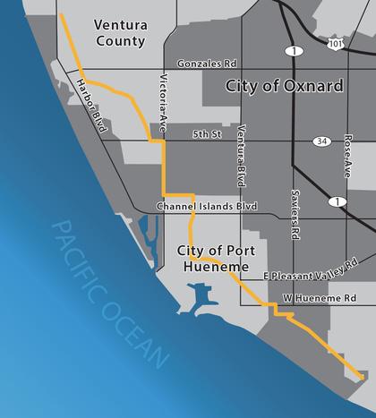
Where is the Coastal Zone Boundary?
The Coastal Zone Boundary is that portion of the land and water area of the City shown on official land use maps of the certified Oxnard Coastal Land Use Plan, and as defined by the coastal zone maps adopted by the Coastal Commission. Official City land use maps depicting the Coastal Zone Boundary can be found below:
How long will the LCP Update take?
The update to the City’s existing LCP is anticipated to take 18 months, beginning in the Fall 2015 and lasting through Spring 2018.
Who can participate in the process?
All residents, business owners, and stakeholders within Oxnard are encouraged to take part in the process and shape the future of their community.
How can I participate?
The LCP Update project began in October 2015, with a pair of kickoff meetings. You can also sign up to receive emails regarding project progress, meetings, and other project related information.
- Meeting Information
- Email Updates – Coming soon.
Where can I find the City’s existing LCP?
The City’s existing LCP documents can be found at the link listed below:
Vulnerability Assessment Report Modeling
Why was Coastal Resilience modeling used in the Vulnerability Assessment Report?
The Oxnard’s Local Coastal Plan Update, of which the Vulnerability Assessment Report is a key component, relies on Coastal Resilience modeling funded by The Nature Conservancy, County of Ventura and the State of California. The City of Oxnard did consider several options when choosing how it would gather data for its Vulnerability Assessment Report. The ideal method would take into account a variety of factors to create the most thorough and accurate prediction model possible. The Coastal Resilience model was chosen since it draws on event- and site-specific information to assess coastal hazards for vulnerability and adaptation planning. Coastal Resilience modeling replicates observed flooding, and has a wide variety of model outputs for coastal erosion, flooding and tidal inundation. To confirm the effectiveness of the Coastal Resilience modeling method, photographic and video evidence was gathered for specific locations and storm events in Oxnard. These were then compared with maps generated using the three available coastal hazard models: Coastal Resilience, Federal Emergency Management Agency (FEMA) flood mapping, and CoSMoS 3.0. The Coastal Resilience model was found to do the best job of predicting areas of flooding during specific storms in Oxnard. Additionally, the Coastal Resilience modeling has evaluated likely adaptation strategies which allow for a more in depth assessment of economic and vulnerability tradeoffs. Experts in a variety of related fields have reviewed the results of the Coastal Resilience modeling and additional input was contributed by the planning departments of both the City of Oxnard and County of Ventura during its development.
Why was FEMA modeling not used?
The Federal Emergency Management Agency (FEMA) provides flood service maps for flood hazard information in support of the National Flood Insurance Program (NFIP). Even though these maps are utilized for flood insurance purposes, they do not incorporate the effects of sea level rise. Sea level rise and the changing climate present management challenges of a new magnitude, with the potential to significantly threaten many coastal resources, including shoreline development, coastal beach access and recreation, habitats, agricultural lands, cultural resources, and scenic resources, all of which are subject to specific protections and regulations in the Coastal Act. Therefore, effective implementation of the Coastal Act and the protection of California’s coast must address global sea level rise and the greater management challenges it will bring (California Coastal Commission 2015). Consequently, the FEMA maps could not be used to evaluate coastal hazards for Oxnard’s Local Coastal Plan Update.
Why was CoSMos modeling not used?
The Coastal Storm Modeling System, or CoSMoS, is a system for predicting storm-related coastal flooding developed by the United States Geological Survey. CoSMoS does take into account the effects of sea level rise and does an excellent job of predicting and mapping changes in dynamic water levels from waves during extreme tides and storms. CoSMoS does not, however, include the effects of maximum wave run-up in its analysis (i.e., the full extent water could be carried inland by waves). In some cases, the incorporation of maximum wave run-up could result in a six foot difference in elevation of waves along the shore. Because Oxnard’s coastal infrastructure (houses, roads, buildings, etc.) are in close proximity to shore, the effects of wave run-up can be severe. Therefore, because CoSMoS does not include the full extent of the hazards posed by large-scale wave and flooding events, it was decided that Coastal Resilience modeling would not be an appropriate coastal hazard model.
Coastal Zone Boundary in Oxnard